
|
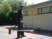
Geophysicist Operating Fisher TW-6 M-Scope Pipe and Cable Locator |
Applications: |
|
Our experience shows that private utility location prior to drilling or excavating saves money on costly utility repairs and can even save lives. AGS personnel are highly trained and have broad experience in locating utilities. Attention to detail and accuracy, professional concern, and state-of-the-art equipment are just a few of the reasons to call AGS for your utility locating needs. These needs cover a wide ranges of applications: · Clear drilling locations for utilities or other potential drilling obstructions · Mark out specific utilities for repair or replacement · Detect subsurface junction boxes, manways, etc. · Complete site-wide utility location to create or update a utility map at any stage of construction or development · Locate electrical or other utility conduits as well as rebar embedded in concrete prior to coring · Identify utility trenches that may represent contaminant pathways
|
|
· Electric · Natural Gas · Water · Storm Drain · Sanitary Sewer · Fuel Oil Lines · Reclaimed Water · Telephone · Fiber Optic (Limited) · Unknown Type or Abandoned |
|
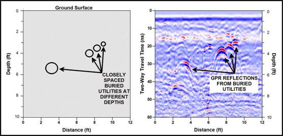
GPR can be used to help locate underground utilities in congested or complicated areas and under reinforced concrete, where conventional line locating techniques may fail. The image above (left) shows four closely spaced buried utilities with different sizes and occurring at different depths. The GPR cross-sectional profile (above right) shows GPR reflections from a traverse over these utilities that easily resolves the four utilities. AGS has found that GPR provides an additional layer of confidence to the typical utility locating procedures used during borehole clearance work to ensure safe drilling practices. |
|
Utility Location |

|
Advanced Geological Services |
|
Providing Comprehensive Geophysical Solutions |
Utility Types: |
Procedures: |
|
AGS provides geophysicists to do all utility locating work. Their understanding of the geophysical principles behind the equipment and detection methods results in more reliable and accurate utility markouts than those provided by service technicians. · AGS uses multiple instruments to locate utilities. These may include: · Radiodetection RD4000—Radiofrequency detection unit · Fisher M-Scope—Metal Pipe and Cable Locator · EM-31– Terrain Conductivity Meter · GPR—Ground Penetrating Radar These overlapping technologies increase the ability to detect most utilities. Using the RD4000, active electric lines may be detected using a passive receiver. Also, a signal may be directly connected to or induced on a line using a transmitter to trace its subsurface location. The M-Scope is an EM induction instrument that assists in locating metal pipes and conduits, even abandoned, non-continuous lines. The EM-31 is also an EM induction instrument that can detect deeper pipelines as well as utility trenches in some cases. GPR is used to confirm locations of utilities and trenches detected with the EM techniques and also allows for detection of non-metallic utilities such as those constructed of pvc, concrete, clay and fiberglass. |
|
Often our clients require only an on-site mark-out. Detected utility locations are marked on the ground surface with spray paint. In many cases, our clients also need a map of the detected utilities. AGS provides accurate maps of all detected features using CAD, by either updating client-supplied site-maps or generating detailed scaled maps from field sketches. |
Results: |