|
Advanced Geological Services |
|
Providing Comprehensive Geophysical Solutions |


|
Borehole logging involves gradually lowering a tool (or probe) down a completed borehole, while the probe measures a physical property of the surrounding rock or soil. Different probes measure different physical properties or borehole characteristics. |
|
BOREHOLE LOGGING |

|
The Gravity method is used to measure subtle variations in the earth’s gravitational field. These variations are related to subsurface material density and can be used to map sedimentary basins, tunnels, voids, caves, etc. |
|
GRAVITY |

|
AGS has a reputation for developing innovative approaches to non-invasive geophysical investigations. AGS' in-depth understanding of the benefits and limitations of various geophysical technologies allows us to provide our clients with cost effective geophysical surveys. This allows our clients the opportunity to reduce the overall cost and liability in engineering, construction and environmental projects. We accomplish this by providing clients with highly trained professionals for field acquisition, data interpretation and reporting. AGS' experience with a broad range of clients and industries combined with our professional staff's geological background ensures our clients receive practical solutions to their problems. Depending on the client's needs and the geological characteristics of the site, AGS commonly employs one or more of the following geophysical technologies: |
|
Geophysical Methods |


|
GPR is typically used to image subsurface conditions from 0 to 10 feet in depth. It can specifically identify underground storage tanks, utilities, rebar, and more. |
|
GROUND PENETRATING RADAR (GPR) |
|
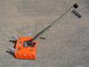
A variety of common geophysical instruments use the principles of electromagnetic induction to detect buried metallic and non-metallic objects or other changes in subsurface soil conditions. |
|
ELECTROMAGNETIC INDUCTION |
|
Seismic surveys are commonly used for shallow investigations such as determining engineering properties (downhole p– and s-wave velocity), mapping the bedrock interface, and environmental studies. |
|
SEISMIC METHOD |

|
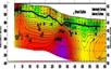
ELECTRICAL RESISTIVITY |

|
Mapping variations in the magnetic field throughout a survey area provides information on locations of buried metal such as USTs, lost wells, debris and more. |
|
MAGNETIC METHOD |